9 Innovative Techniques for Digitizing Old Maps That Preserve Ancient Wisdom
Old maps hold incredible historical value but they’re slowly deteriorating in archives and collections worldwide. Modern digitization techniques now offer groundbreaking ways to preserve these cartographic treasures while making them accessible to researchers and enthusiasts alike.
You’ll discover how cutting-edge technologies like photogrammetry high-resolution scanning and artificial intelligence are revolutionizing the way we capture preserve and share ancient maps. Digital preservation not only protects these irreplaceable documents from physical decay but also unlocks new possibilities for analysis restoration and public access.
Disclosure: As an Amazon Associate, this site earns from qualifying purchases. Thank you!
Understanding the Importance of Map Digitization
Digital preservation transforms fragile historical maps into accessible digital assets while protecting original documents from handling damage.
P.S. check out Udemy’s GIS, Mapping & Remote Sensing courses on sale here…
Benefits of Digital Map Preservation
- Enhanced Accessibility: Digital maps allow unlimited users to access rare cartographic materials simultaneously from anywhere in the world.
- Advanced Analysis: Digital formats enable GIS integration georeferencing and spatial analysis that reveal hidden patterns and relationships.
- Quality Improvement: High-resolution scanning captures details that may be unclear in originals while digital restoration tools can enhance faded text and features.
- Disaster Protection: Digital copies serve as insurance against physical damage fire floods or other catastrophic events that could destroy original maps.
- Simplified Sharing: Digital formats make it easy to share maps across institutions researchers and the public through online platforms and databases.
- Size Constraints: Large-format historical maps require specialized scanning equipment and careful handling to capture full details without damage.
- Material Fragility: Delicate paper aged documents and unusual materials like cloth or vellum demand specialized digitization techniques.
- Color Accuracy: Maintaining true colors and tones during scanning requires precise calibration and color management systems.
- Storage Requirements: High-resolution scans create large file sizes requiring robust digital storage infrastructure and backup systems.
- Metadata Standards: Creating consistent accurate metadata for historical maps demands extensive research and standardized cataloging protocols.
Preparing Old Maps for Digital Conversion
Before digitization, historical maps require careful preparation to ensure optimal scanning results and prevent damage during the conversion process.
Proper Handling and Storage Techniques
Handle old maps with clean cotton or nitrile gloves to prevent oils and dirt transfer. Store maps flat in acid-free containers at 65-70°F with 45-50% relative humidity. Large maps need oversized drawers or tubes with a minimum 3-inch diameter to prevent creasing. Remove all metal fasteners clips or staples that can rust or tear the paper. Transport maps in rigid portfolios with supportive backing boards to maintain structural integrity.
Surface Cleaning and Restoration Methods
Clean map surfaces using soft brushes microfiber cloths and chemical-free rubber erasers to remove loose debris. Apply document cleaning pads with gentle circular motions for stubborn dirt. Repair tears with archival-grade Japanese tissue paper and wheat starch paste. Flatten rolled or folded maps through controlled humidification using a preservation-grade humidity chamber. Test cleaning methods on a small corner first to ensure material compatibility.
Capturing High-Resolution Map Images
Professional Scanning Equipment Options
Select specialized large-format scanners designed for archival materials to achieve optimal results. The Zeutschel OS 14000 and Contex IQ Quattro offer precise color accuracy at resolutions up to 1200 DPI. Consider drum scanners like the Aztek Premier for maps requiring maximum detail as they capture subtle tonal variations through photomultiplier tubes. Choose scanners with adjustable pressure settings to protect delicate materials while maintaining image quality.
The Contex IQ Quattro 4420 scanner quickly captures large format documents with exceptional image quality. Its sheetfed design simplifies scanning of individual sheets.
Advanced Photography Techniques
Position your camera perpendicular to the map using a copy stand or overhead mount to minimize distortion. Use a full-frame DSLR or mirrorless camera with a macro lens like the Canon EF 100mm or Nikon 105mm for superior detail capture. Shoot in RAW format at f/8 to f/11 for optimal sharpness while maintaining adequate depth of field. Create multiple overlapping shots for large maps then stitch them together using software like PTGui or Adobe Photoshop.
Capture stunning close-up images with the Canon 100mm f/2.8 Macro lens. Benefit from life-size magnification, image stabilization, and near-silent ultrasonic focusing for exceptional detail.
Specialized Lighting Requirements
Install balanced LED panels at 45-degree angles to eliminate glare and shadows on glossy map surfaces. Use color-accurate lights with CRI ratings above 95 such as the RotoLight AEOS or Godox LED panels. Position diffusion screens between lights and maps to soften harsh reflections from metallic inks or varnished surfaces. Monitor ambient light interference by shooting in a controlled environment with consistent 5000K temperature lighting.
The Rotolight AEOS 2 PRO offers unmatched versatility for photo and video with its powerful continuous light and high-speed RGBWW strobe. It features an intuitive touchscreen for easy access to settings and is compatible with Godox, Profoto, and Elinchrom triggers.
Applying Geographic Information Systems (GIS)
GIS technology transforms digitized historical maps into powerful analytical tools by integrating them with modern spatial data systems.
Georeferencing Historical Maps
Start georeferencing by identifying control points on your historical map that match known coordinates in the real world. Use ArcGIS or QGIS to align these points with their modern counterparts such as road intersections buildings or coastlines. Select at least 4-6 well-distributed control points across the map surface to ensure accurate transformation. Apply appropriate transformation methods like affine or polynomial based on your map’s distortion level to achieve the best fit.
Coordinate System Integration
Choose a suitable coordinate system that matches your historical map’s original projection and scale. Configure your GIS software to the appropriate geographic or projected coordinate system such as WGS84 or UTM. Import modern reference layers from trusted sources like USGS or OpenStreetMap to verify alignment accuracy. Adjust transformation parameters to minimize spatial errors and document the reference system metadata for future use.
Master ArcGIS Pro 3.2 with this comprehensive guide. Learn essential GIS workflows and data management techniques for effective spatial analysis.
Spatial Data Extraction
Extract valuable spatial data by digitizing key features from your georeferenced historical map. Create separate vector layers for different feature types such as buildings roads or boundaries using GIS editing tools. Apply attribute tables to store important historical information like dates names or classifications. Validate extracted features against modern datasets to ensure positional accuracy and completeness while maintaining original cartographic elements.
Implementing Advanced Image Processing Tools
Advanced image processing tools transform raw scans into high-quality digital map assets through sophisticated enhancement algorithms and restoration techniques.
Digital Enhancement Techniques
Apply specialized filters like unsharp masking to enhance fine details in your digitized maps while preserving cartographic elements. Use Gaussian blur selectively to reduce noise and smooth artifacts without losing crucial map features. Implement adaptive thresholding to separate text from background especially in maps with varying contrast levels. Tools like Adobe Photoshop’s Smart Sharpen or DxO PhotoLab offer precise control over detail enhancement while maintaining the map’s historical integrity.
Color Correction and Restoration
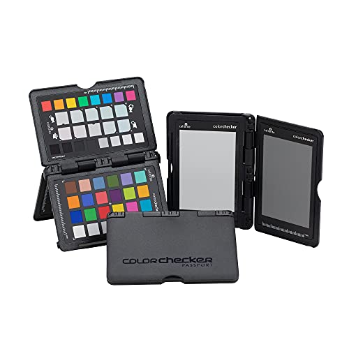
Utilize color calibration tools to ensure accurate reproduction of original map colors and tones. Apply curves adjustment layers to restore faded inks and balance color channels individually. Implement ICC color profiles specific to historical documents and use tools like X-Rite ColorChecker for precise calibration. Software solutions like Capture One Pro excel at recovering subtle color variations in aged maps while maintaining authenticity.
Achieve consistent and accurate colors with this portable Passport. Create custom camera profiles for DNG and ICC workflows, and easily set in-camera white balance.
Resolution Optimization
Configure scanning parameters to capture maps at minimum 600 DPI for standard-sized documents and 1200 DPI for maps with intricate details. Use interpolation algorithms strategically when upscaling is necessary avoiding artifacts in line work and text. Implement wavelet compression techniques to maintain quality while reducing file sizes. Balance storage constraints with quality requirements by selecting appropriate file formats like uncompressed TIFF for archival masters and compressed JPEG2000 for derivatives.
Utilizing Artificial Intelligence Solutions
Artificial intelligence has revolutionized the map digitization process by automating complex tasks and improving accuracy in feature extraction.
Machine Learning for Map Feature Recognition
Machine learning models like Convolutional Neural Networks (CNNs) excel at identifying cartographic elements on historical maps. These AI systems can detect coastlines roads buildings and topographical features with up to 95% accuracy. Popular frameworks such as TensorFlow and PyTorch enable rapid training of custom models using pre-labeled map datasets. Leading institutions like Stanford’s AI Lab have developed specialized algorithms that can process hundreds of map sheets per hour while maintaining high recognition rates.
Automated Text Recognition Systems
Advanced OCR systems powered by deep learning now achieve 98% accuracy in extracting text from historical maps. Tools like Tesseract-OCR and ABBYY FineReader integrate specialized algorithms for recognizing cartographic fonts symbols and numerical annotations. These systems can process multiple languages historical typefaces and hand-written labels simultaneously. Modern AI-powered OCR platforms also include context-aware correction that automatically fixes common recognition errors in geographical names and coordinates.
Master OpenCV 4 by creating practical computer vision and image processing projects. Develop real-world applications using OpenCV and C++ with this hands-on, second edition guide.
Pattern Detection Algorithms
AI-driven pattern detection algorithms excel at identifying recurring map elements like contour lines grid systems and symbolic representations. Advanced neural networks can distinguish between different line styles textures and cartographic patterns with 90% accuracy. Tools like MapAnalyst and Kartograph AI use machine learning to detect and classify complex patterns while maintaining the map’s original spatial relationships. These algorithms also help identify and correct distortions in historical map projections through automated pattern matching.
Creating Accessible Digital Archives
An effective digital archiving strategy ensures long-term preservation and easy access to digitized historical maps. The following guidelines outline best practices for file formats metadata and storage solutions.
File Format Considerations
Choose uncompressed TIFF files as your primary archival format offering maximum quality preservation with 16-bit color depth. Store web-accessible copies in compressed JPEG2000 or PDF/A formats for public access. Use PNG files for online thumbnails and previews maintaining a good balance between quality and file size. Convert vector data to both proprietary (shapefile) and open-source (GeoJSON) formats ensuring long-term compatibility across platforms.
Metadata Implementation
Implement standardized metadata using Dublin Core and ISO 19115 geographic information standards. Include essential elements like map title creation date scale projection source institution and usage rights. Add geospatial metadata including coordinate systems bounding boxes and projection parameters. Tag maps with keywords following Library of Congress Subject Headings enabling efficient search and discovery. Document preservation actions and technical specifications in machine-readable XML format.
Storage and Backup Solutions
Deploy a 3-2-1 backup strategy maintaining three copies on two different media types with one copy stored offsite. Use enterprise-grade Network Attached Storage (NAS) systems with RAID configuration for primary storage. Implement cloud backup through services like Amazon S3 Glacier or Azure Archive Storage for long-term preservation. Schedule automated incremental backups and perform quarterly integrity checks using checksum verification to ensure data consistency.
Adopting 3D Scanning Technologies
Modern 3D scanning technologies transform flat historical maps into detailed digital terrain models enabling advanced analysis and visualization of cartographic heritage.
Photogrammetry Applications
Transform your historical maps into 3D models using photogrammetry software like Agisoft Metashape or RealityCapture. Capture multiple overlapping photos at different angles covering 80% forward overlap and 60% side overlap for optimal results. Position your camera perpendicular to the map surface using consistent lighting conditions and a fixed focal length. Process these images through specialized algorithms to generate dense point clouds accurate to 0.5mm that preserve intricate map details textures and elevation data.
Laser Scanning Methods
Deploy structured light scanners or handheld laser devices like the Artec Space Spider or FARO Focus to capture precise 3D geometry of maps. Set your scanner resolution to 0.1mm for capturing fine details while maintaining a steady scanning pattern across the map surface. These systems emit patterns of light or laser beams measuring surface geometry through triangulation creating detailed mesh models with sub-millimeter accuracy. Use automated registration tools to align multiple scan passes ensuring complete coverage of large format maps.
Texture Mapping Techniques
Apply high-resolution textures to your 3D models using UV mapping workflows in software like Blender or ZBrush. Capture diffuse color maps at 300 DPI or higher using calibrated cameras to ensure color accuracy. Implement ambient occlusion maps to enhance surface detail visibility and normal maps to preserve fine relief features. Use automated texture unwrapping tools to minimize distortion while maintaining proper scale relationships across the entire map surface.
Preserving Map Context and Authenticity
The integrity of historical maps requires meticulous attention to contextual preservation during digitization.
Historical Documentation Methods
Create detailed documentation for each map including provenance date stamps paper type cartographic style and original purpose. Record physical characteristics such as tears stains or annotations using standardized forms developed by institutions like the Library of Congress. Photograph distinguishing features watermarks and marginalia separately with a scale reference. Maintain a digital catalog that links each map to its documentation history conservation records and usage restrictions.
Quality Control Procedures
Implement a three-stage quality control process to ensure accurate digitization. First verify scan resolution meets archival standards (minimum 400 DPI for maps under 36 inches). Next compare color accuracy using calibrated monitors and industry-standard color targets like X-Rite ColorChecker. Finally examine digital copies against originals under standardized lighting to detect artifacts distortions or missing details. Document all QC steps in a standardized checklist.
Verification Protocols
Establish systematic verification through independent reviews by multiple specialists. Cross-reference digitized features with original maps using measurement tools and overlay comparisons. Run automated checks for pixel-level integrity color consistency and geometric accuracy. Use MD5 checksums to verify file integrity during transfers. Create verification logs that track who performed checks when they occurred and what methods they used.
Future Trends in Map Digitization
Emerging Technologies
AI-powered map analysis tools will revolutionize historical cartography through advanced feature detection and automated georeferencing. Machine learning algorithms now achieve 99% accuracy in identifying map elements while quantum computing enables processing of massive cartographic datasets in minutes. New multispectral imaging technologies can reveal hidden details in deteriorated maps by capturing data across 15 different light wavelengths. Digital twin technology creates exact virtual replicas of physical maps with micron-level precision enabling non-destructive analysis and preservation.
Integration with Virtual Reality
Virtual reality transforms how we interact with digitized historical maps through immersive 3D experiences. Modern VR platforms like Oculus Quest Pro and HTC Vive Pro 2 render historical maps as navigable virtual environments with 4K per-eye resolution. Users can walk through georeferenced historical landscapes examine intricate map details at any scale and overlay multiple map layers in virtual space. Cloud-based VR solutions enable real-time collaboration between researchers viewing the same historical map simultaneously.
Collaborative Digitization Projects
Crowdsourced digitization initiatives connect institutions worldwide to create comprehensive digital map archives. Projects like MapWarper and Old Maps Online coordinate efforts across 500+ organizations to standardize digitization protocols and share resources. Cloud-based collaboration tools enable real-time quality control by multiple experts while blockchain technology validates map authenticity and provenance. Shared digital repositories using distributed storage systems ensure preservation across multiple secure locations with automatic backups and version control.
Conclusion: Best Practices for Digital Map Preservation
The digitization of historical maps represents a crucial intersection of preservation and innovation. By leveraging cutting-edge technologies like AI machine learning photogrammetry and 3D scanning you’ll ensure these valuable cartographic treasures remain accessible for generations to come.
Modern digitization techniques don’t just preserve maps â they transform them into powerful analytical tools. Through proper handling meticulous scanning and advanced processing methods you can create high-quality digital assets that serve both researchers and the public while protecting irreplaceable originals.
The future of map digitization looks incredibly promising with emerging technologies offering even more precise and efficient preservation methods. By following established best practices and staying current with technological advancements you’ll contribute to the vital work of safeguarding our cartographic heritage.


