10 Best Mapping Journals for Documenting Fieldwork That Enhance Precision
Documenting fieldwork can be a game-changer for researchers and adventurers alike. The right mapping journal not only helps you capture vital information but also enhances your overall experience. Discover the best options that combine functionality and creativity to elevate your fieldwork documentation.
Rite in the Rain Field Notebook
Designed for durability, this waterproof journal lets you document in wet conditions. Its rugged cover holds up against the elements while its grid format assists in precise mapping.
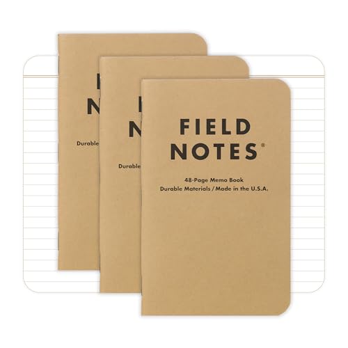
Field Notes Memo Books
This pocket-sized 3-pack of Field Notes notebooks is ideal for on-the-go note-taking. Each notebook features 48 pages of lined, acid-free paper for smooth writing and durable kraft cardstock covers for everyday carry.
Compact and versatile, these notebooks easily fit in your pocket. Use them for quick sketches and notes, with various paper types available to suit your mapping style.
Moleskine Art Collection Sketchbook
Unleash your creativity with Moleskine Art notebooks, featuring high-quality paper ideal for various mediums. The durable cover and elastic closure keep your projects secure on the go.
This premium sketchbook features heavy-duty pages perfect for detailed maps. It’s an excellent choice for artists needing a reliable medium for ink and watercolor.
Leuchtturm1917 Bullet Journal
This notebook is designed for bullet journaling, featuring a bullet key, index, future log, and a helpful pocket guide. Enjoy 204 numbered dot-grid pages with smart grid markers and sustainably-sourced 120 GSM paper, plus a sticker sheet to organize your layouts.
Known for its organization features, this journal includes numbered pages and an index. Use it to create structured mapping notes and to index your field observations effectively.
Blackwing 602 Journal
This portable 5" x 8.25" notebook features 160 pages of high-quality, acid-free paper. It includes a Blackwing pencil and lies flat for comfortable writing.
Combine writing and mapping with this elegant journal that offers smooth pages for pencil sketches. Its graphite-friendly surface provides excellent results for rough drafts of your maps.
Lamy Safari Fountain Pen
Use this pen for precision and control when drafting in your journal. Its smooth flow allows for fine detail work, enhancing your mapping capabilities during fieldwork.
Graphing Paper Notebooks
Organize assignments and projects with this durable Mead spiral notebook. It features 100 graph-ruled sheets with clean-tear perforations and is three-hole punched for binder storage.
Ideal for technical mapping, these notebooks support precise scaling and grid work. They’re perfect for plotting coordinates and contours, catering to your technical mapping needs.
Incorporate these journals and tools into your fieldwork to capture meaningful and accurate data, ensuring your mapping practices are effective and efficient.
Benefits of Using Mapping Journals
Using mapping journals can significantly enhance your documentation of fieldwork. They provide structured ways to capture spatial data, improve your observational skills, and facilitate data organization.
Enhancing Observational Skills
You’ll find that mapping journals encourage you to sharpen your observational skills. By sketching maps, taking notes, or annotating diagrams, you engage deeply with your environment. This process allows you to notice details you might otherwise overlook, such as subtle landforms or vegetation changes. Utilizing tools like the Rite in the Rain Field Notebook will help you maintain legible records even in harsh weather, enhancing your ability to capture precise observations.
Improving Data Organization
You can improve how you organize your data with effective mapping journals. Structured formats allow you to categorize information clearly, which is essential for later analysis. For instance, the Leuchtturm1917 Bullet Journal offers pre-made sections that help you maintain organized records of your field observations, sketches, and notes. By keeping everything in one place, you’ll streamline your workflow and reduce the risk of losing critical data. This organized approach ensures your mapping process is efficient and productive.
Types of Mapping Journals
When it comes to documenting fieldwork, you can choose between physical and digital mapping journals, each type serving unique purposes and addressing different needs.
Physical Mapping Journals
Physical Mapping Journals are traditional tools that allow you to capture your observations manually. You might prefer using a durable notebook like the Rite in the Rain Field Notebook, designed for wet conditions, ensuring that your notes remain legible. Many professionals opt for graphing paper notebooks, enabling precise mapping through structured grids. These journals encourage a tactile exploration of your environment, fostering a deeper connection to your surroundings.
Digital Mapping Journals
Digital Mapping Journals offer a modern approach to documenting fieldwork, allowing you to integrate technology seamlessly. Applications such as ArcGIS Collector enable real-time data collection and mapping on mobile devices. Another popular choice is QGIS, which offers extensive tools for spatial analysis and visualization. Digital formats allow for easy editing and sharing of your data, enhancing collaboration and accessibility. Moreover, employing cloud storage ensures your work is backed up and readily available from different devices.
Criteria for Choosing the Best Mapping Journals
Selecting the appropriate mapping journal for your fieldwork involves evaluating several essential factors. Here’s what you should consider to make an informed decision.
Size and Portability
You’ll want a journal that’s compact and lightweight for ease of transport. Field Notes: Expedition Notebooks, measuring 3.5″ x 5.5″ and weighing just 1.3 ounces, represent an excellent choice due to their portability. Look for journals that fit comfortably into your pack without adding unnecessary bulk, enabling quick access in dynamic field conditions.
Page Layout and Design
You need a well-designed page layout to optimize your mapping and note-taking activities. The Field Notes: Expedition Notebooks feature versatile dot-graph paper, perfect for both sketches and notes. Similarly, the Rite in the Rain Universal Notebook offers a ruled grid layout, ideal for precise measurements. Ensure your journal allows for clear organization of data, making it easier to reference later.
Durability and Weather Resistance
You should prioritize durability and weather resistance in your mapping journal. Journals like the Rite in the Rain Field Notebook are designed specifically for harsh conditions, ensuring that your records remain legible even in wet weather. Look for materials resistant to tearing and fading, as they contribute to the longevity of your notes during field research.
Top Picks for the Best Mapping Journals for Documenting Fieldwork
When it comes to fieldwork documentation, choosing the right mapping journal can significantly enhance your experience. Here are some top picks to consider:
Journal 1: Journal of Maps (JoM)
Features: The Journal of Maps is a fully open access, inter-disciplinary journal that publishes maps and spatial diagrams. It emphasizes social and physical processes on a geographical scale, using visuals to advance understanding.
Benefits: JoM supports an open peer review policy, ensuring transparency. All articles are freely available online, making it a valuable resource for multidisciplinary contributions, perfect for diverse fieldwork documentation needs.
Journal 2: Cartographica
Features: Cartographica is a prestigious journal recognized within the cartography community, focusing on theoretical and practical aspects of mapping. It covers various topics that address both historical and contemporary mapping practices.
Benefits: Cartographica provides rigorous academic insights, enhancing your mapping skills. It’s an excellent avenue for staying up-to-date with the latest trends and innovations in cartography, allowing you to apply contemporary methods in your fieldwork documentation.
Journal 3: The Annals of the American Association of Geographers
Features: This journal is a leading publication that features cutting-edge research in geography, including advanced mapping techniques. It offers articles on spatial analysis and issues relevant to both human and physical geography.
Benefits: The Annals allows you to access high-quality research that can inform your mapping projects. Integrating findings and methodologies from this journal can improve your technical knowledge and practical applications in the field.
Tips for Effectively Using Mapping Journals
Using mapping journals can greatly enhance your fieldwork documentation process. Here are some practical tips to maximize their effectiveness.
Regular Entries and Updates
Keep your entries consistent by writing regularly in your mapping journal. Make it a habit to record observations daily or weekly, noting environmental changes, spatial patterns, and your experiences. For instance, use timestamped entries for touchpoints in long-term projects, which can be crucial for tracking changes over time. This practice not only boosts organization but also aids in recalling essential details when compiling data for analysis.
Incorporating Sketches and Diagrams
Integrate sketches and diagrams into your mapping journal to create a rich, visual narrative of your fieldwork. Use quick sketches to capture site layouts, elevation changes, or unique features, as they can help you remember nuanced details that text alone cannot convey. Consider adopting graphing techniques for more precise spatial relationships, utilizing tools like colored pencils or markers to enhance clarity and engagement. These visual elements can serve as reference points when transferring data to digital platforms, strengthening your overall mapping quality.
Conclusion
Choosing the right mapping journal can transform your fieldwork experience. With options that cater to various needs and environments you can find a journal that suits your style. Whether you prefer the rugged durability of Rite in the Rain or the sleek elegance of a Moleskine your choice will impact how effectively you document your observations.
Remember to engage with your surroundings and make regular entries. Incorporating sketches and diagrams not only enhances your records but also deepens your connection to the environment. By selecting a suitable mapping journal and following effective documentation practices you’ll enrich your fieldwork and capture valuable insights that last.


