11 Ways 3D Modeling in Cartography Transforms Digital Map Creation
The evolution of cartography has taken a dramatic leap forward with 3D modeling technology transforming how we visualize and interact with maps. Whether you’re a professional cartographer or a geography enthusiast you’ll find that 3D modeling adds depth perception clarity and enhanced spatial understanding to traditional mapping methods.
Modern cartography now lets you explore terrain features urban landscapes and geological formations in stunning detail with interactive 3D maps that bring geographic data to life. From urban planning to environmental conservation these advanced visualization techniques have revolutionized how we understand and analyze our world providing unprecedented insights that were impossible with traditional 2D maps.
Disclosure: As an Amazon Associate, this site earns from qualifying purchases. Thank you!
Understanding the Evolution of 3D Modeling in Modern Cartography
Traditional Mapping vs. 3D Cartographic Modeling
Traditional cartography relied on 2D paper maps with contour lines elevation symbols and shading to represent terrain. Modern 3D modeling transforms these flat representations into dynamic interactive visualizations. Digital 3D maps allow users to rotate pan and zoom through landscapes examining topography from multiple angles. While traditional maps use symbols and legends 3D models create realistic representations of buildings vegetation and infrastructure with precise spatial relationships and elevation data. This shift enables better understanding of geographic relationships terrain analysis and urban planning applications.
Key Technological Advances in Digital Mapping
The evolution of 3D cartography stems from several breakthrough technologies. LiDAR scanning enables precise terrain mapping by using laser pulses to capture millions of elevation points. Photogrammetry software converts aerial photographs into detailed 3D models through image matching algorithms. Geographic Information Systems (GIS) now integrate real-time data processing with powerful 3D rendering capabilities. Cloud computing platforms handle massive geographic datasets while enabling collaborative mapping projects. Advanced graphics processors render complex 3D landscapes with photorealistic textures shadows and lighting effects. These innovations create increasingly accurate and immersive cartographic experiences.
Essential Tools and Software for 3D Cartographic Modeling
Creating professional 3D cartographic models requires a combination of specialized software tools and data processing technologies.
Industry-Standard 3D Mapping Programs
ArcGIS Pro leads the industry with powerful 3D mapping capabilities including terrain modeling scene creation and volumetric analysis. QGIS offers robust open-source alternatives with its 3D visualization plugin and DTM tools. For specialized terrain modeling SketchUp Pro and AutoCAD Civil 3D excel at creating detailed topographic surfaces. Blender provides advanced 3D modeling features perfect for custom cartographic elements while Global Mapper streamlines the import and processing of elevation data from multiple sources.
Master SketchUp Pro with this comprehensive guide. Learn to leverage extensions and Layout for powerful 3D modeling and design workflows.
Data Collection and Processing Technologies
LiDAR systems generate high-resolution point clouds capturing precise terrain details at up to 1 million points per second. Digital photogrammetry software like Agisoft Metashape and Pix4D transform aerial imagery into detailed 3D models through automated processing. GPS/GNSS receivers collect accurate ground control points with sub-meter precision. Structure-from-Motion (SfM) technology creates 3D models from overlapping photos while bathymetric sonar systems map underwater terrain features with centimeter-level accuracy.
Learn survey mapping quickly with the Metashape Pro guide. Master essential photogrammetry techniques step-by-step for accurate 3D model creation.
Creating Detailed Terrain Visualization Through 3D Modeling
Digital Elevation Models and Surface Representations
Digital Elevation Models (DEMs) form the foundation of 3D terrain visualization. You’ll create accurate surface representations using raster-based elevation data with resolutions ranging from 30 meters to sub-meter precision. LiDAR-derived DEMs offer superior detail capturing terrain features like valleys ridges and peaks. Modern DEM processing techniques including TIN (Triangulated Irregular Network) models enable precise surface interpolation while maintaining data efficiency through adaptive mesh resolution.
Texture Mapping and Material Properties
Texture mapping enhances terrain models with photorealistic surface details. You’ll apply high-resolution satellite imagery orthorectified aerial photos and custom texture maps to create visually rich landscapes. Material properties define surface characteristics like reflectivity roughness and displacement mapping. Modern rendering engines support PBR (Physically Based Rendering) workflows allowing realistic representation of different terrain types from rocky outcrops to vegetation-covered slopes.
Integration of Geographic Information Systems (GIS)
GIS integration enables dynamic analysis of 3D terrain data. You’ll combine elevation models with vector layers including land use boundaries hydrological networks and infrastructure data. Tools like ArcGIS Pro and QGIS support real-time terrain analysis including viewshed calculations slope analysis and watershed delineation. Advanced spatial queries help identify terrain features flood risk zones and optimal development sites while maintaining georeferenced accuracy.
Applications of 3D Cartographic Models in Urban Planning
3D cartographic models transform urban planning by enabling precise visualization and analysis of city landscapes for informed decision-making.
City Development and Infrastructure Mapping
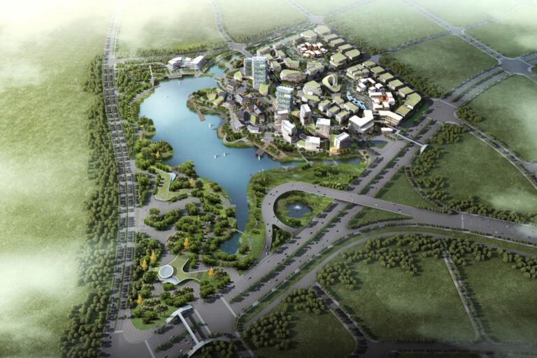
3D cartographic models revolutionize infrastructure planning by creating detailed digital representations of urban environments. These models integrate underground utilities essential elements like water pipes sewage systems power lines and telecommunication networks with above-ground structures. City planners use tools like Esri CityEngine to simulate development scenarios evaluate environmental impact and assess infrastructure capacity. The models enable precise measurements of building heights setbacks and sight lines while supporting sustainable urban growth through accurate spatial analysis.
Create 3D city models from OpenStreetMap data. This German Edition book guides you through the process using Esri CityEngine.
Building Information Modeling (BIM) Integration
BIM integration with 3D cartographic models creates comprehensive digital twins of urban environments. This merger allows planners to analyze building performance energy efficiency and structural integrity within their geographic context. Software platforms like Autodesk Revit and Bentley OpenCities Map combine detailed architectural models with spatial data to support renovation projects assess solar potential and plan emergency responses. The integration enables real-time updates of building information while maintaining geographic accuracy.
Master Autodesk Revit 2025 for integrated building design. Learn to coordinate architecture, structure, and MEP systems effectively in a BIM environment.
Traffic Flow and Population Density Analysis
3D cartographic models enhance traffic and population analysis through dynamic visualization of movement patterns. Tools like VISSIM and ArcGIS Urban simulate pedestrian flows vehicle traffic and public transportation routes in three-dimensional space. These models help identify congestion points optimize transit routes and plan emergency evacuation procedures. Population density analysis becomes more intuitive with 3D visualization showing demographic distributions across vertical developments and enabling better urban service distribution planning.
Environmental and Geological Mapping Applications
Natural Resource Management
3D modeling transforms natural resource management by creating detailed visualizations of forests wetlands mineral deposits. Advanced LiDAR scanning generates precise canopy height models enabling forest inventory analysis with 95% accuracy. Resource managers use tools like ArcGIS Pro’s 3D Analyst to monitor vegetation health track wildlife habitats and plan sustainable harvesting. Underground resource mapping benefits from 3D geological models that display mineral deposits aquifers and soil composition in interactive layers helping optimize extraction strategies while minimizing environmental impact.
Climate Change Impact Visualization
3D cartographic models revolutionize climate change communication by visualizing sea-level rise glacier retreat and coastal erosion patterns. Tools like QGIS’s 3D visualization plugins create time-series models showing projected environmental changes over decades. Scientists use TerrSet’s Earth Trends Modeler to simulate temperature changes vegetation shifts and precipitation patterns with 85% prediction accuracy. These models integrate real-time climate data with topographic information to create dynamic visualizations that help policymakers understand complex environmental changes.
Disaster Risk Assessment Models
3D mapping enhances disaster preparedness through detailed terrain analysis and hazard modeling. Emergency managers use HAZUS-MH software to create flood inundation models with 90% accuracy rates. LaharZ generates 3D volcanic hazard zones while RockWorks creates landslide susceptibility maps. These tools combine high-resolution DEMs with geological data to simulate natural disasters identify vulnerable areas and optimize evacuation routes. Real-time data integration allows emergency responders to update risk assessments during evolving situations.
Understand potential earthquake losses across the U.S. with this FEMA report (366), providing HAZUS® MH estimated annualized data. Access critical insights for risk assessment and mitigation planning.
Interactive 3D Maps for Public Engagement
Interactive 3D maps revolutionize public engagement by transforming complex geographic data into accessible visual experiences. These dynamic tools enable users to explore spatial information through intuitive interfaces and immersive technologies.
Web-Based 3D Mapping Platforms
Modern web platforms like Cesium MapBox GL JS and ArcGIS Online transform cartographic visualization through browser-based 3D mapping. These platforms support real-time rendering of detailed terrain models building footprints and infrastructure networks directly in web browsers. Users can pan zoom and rotate through cityscapes or natural landscapes while accessing embedded data layers population statistics and environmental information. Open-source libraries like Three.js and WebGL enable developers to create custom 3D mapping applications with seamless performance across desktop and mobile devices.
Virtual Reality and Augmented Reality Integration
VR and AR technologies elevate 3D cartographic experiences through immersive spatial visualization. Platforms like ArcGIS 360 VR and Google Earth VR enable users to explore geographic data in virtual environments using head-mounted displays. Mobile AR applications overlay 3D map features onto real-world views through smartphone cameras creating context-aware navigation experiences. These tools transform public engagement by allowing users to virtually walk through proposed urban developments visualize underground infrastructure or explore historical landscapes through interactive 3D reconstructions.
Capture immersive videos with this lightweight, compact 360-degree camera. Record in full 360 or use the wide-angle lens for 180-degree shots; plus, it's dust and water-resistant.
Future Trends in 3D Cartographic Modeling
Artificial Intelligence and Machine Learning Applications
AI-powered algorithms are revolutionizing 3D cartographic modeling through automated feature extraction and classification. Deep learning models like convolutional neural networks (CNNs) now process LiDAR point clouds to identify buildings terrain features and vegetation with 95% accuracy. Machine learning systems streamline the creation of detailed 3D city models by automatically generating building geometries from satellite imagery and street-level photos while intelligent algorithms enhance texture mapping and surface reconstruction processes through pattern recognition.
Real-Time Data Integration
Real-time sensor networks are transforming 3D cartographic models into dynamic digital twins that update continuously. IoT devices feed live environmental data into 3D visualizations tracking everything from traffic patterns to air quality across urban landscapes. Modern platforms like ArcGIS GeoEvent Server and Safe Software’s FME Server enable instant integration of streaming data from sources like weather stations traffic sensors and environmental monitors creating living 3D maps that reflect current conditions with sub-minute latency.
Advanced Visualization Techniques
Next-generation rendering technologies are pushing the boundaries of photorealistic 3D cartographic visualization. Ray tracing algorithms now simulate natural lighting and atmospheric effects while procedural texturing creates ultra-detailed surface materials automatically. Web-based platforms like MapBox GL JS and deck.gl leverage WebGL 2.0 to deliver smooth rendering of massive 3D datasets directly in browsers. The integration of game engine technology like Unreal Engine 5 enables cinematic-quality visualization of geographic data with dynamic shadows realistic water effects and advanced particle systems.
Leveraging 3D Models for Better Decision Making
3D cartographic models transform complex spatial data into actionable insights enabling informed decision-making across multiple sectors.
Analysis and Planning Benefits
- Identify optimal infrastructure placement through detailed terrain analysis and line-of-sight studies
- Calculate precise volumetric measurements for earthwork planning mining operations and flood control
- Perform shadow analysis for solar panel placement urban development and environmental impact studies
- Generate slope stability assessments for construction projects and natural hazard monitoring
- Create viewshed analyses for telecommunications tower placement and visual impact assessments
- Run advanced spatial queries combining elevation contours watershed boundaries and land use data
- Present complex geographic data through intuitive visual storytelling
- Enable real-time exploration of development scenarios during public meetings
- Share interactive 3D models through web platforms for remote stakeholder review
- Demonstrate environmental impacts through before-and-after visualization sequences
- Create flythrough animations highlighting key project features and considerations
- Support collaborative decision-making with shared virtual environments and annotation tools
Conclusion: The Future of 3D Modeling in Modern Cartography
3D modeling has revolutionized how you view interpret and interact with geographic data. It’s transformed cartography from static 2D representations into dynamic interactive experiences that enhance your understanding of spatial relationships.
The convergence of AI machine learning and IoT with 3D cartographic modeling opens exciting possibilities for the future. These technologies will continue pushing boundaries in accuracy detail and real-time visualization making geographic data more accessible and actionable than ever before.
As technology advances you’ll see even more innovative applications across urban planning environmental conservation and public engagement. The future of cartography lies in these immersive 3D experiences that bridge the gap between complex spatial data and intuitive visual understanding.
